
District-wide Local Plans contain policies and proposals which guide decisions on the use and development of land during a prescribed period. They are prepared by District Councils in accordance with relevant National and Regional planning policies, in consultation with all interested parties and organisations and the general public.
The current Local Plan for South Northamptonshire was adopted by South Northamptonshire Council in 1997. The Council is preparing a replacement plan for the period up to 2029 which will, amongst other things, establish a Rural Settlement Hierarchy for settlements within the District; propose amendments to existing town and village confines lines, beyond which expansion will not normally be permitted; identify areas of important open space within settlements and address local development needs.
After a period of public consultation, the Draft Local Plan is submitted to government for approval. This involves an “examination in public” before an Inspector, where matters of common interest or concern are considered together, more informally than at a Public Inquiry. The Inspector’s brief is to ensure that the policies of the plan do, indeed, conform to current government planning policy guidance.
Click here to see the comments made, including those by Sulgrave Parish Council.
We have now reached the actual Submission stage and the Plan is once more available for comment before it goes to the Inspector. As far as Sulgrave is concerned, a careful examination of the latest version of the plan reveals that there are no significant changes, other than a slight modification of the village confines line which is described on the next page.
As set out at the end of this item on the next page, comments on this latest version of the Local Plan must be lodged with the South Northants Council not later than noon on Friday 16th November.
Click on “read the rest of this entry”.
For the purpose of the Local Plan, Sulgrave is designated as a “Small Village”. In these villages there will be scope for very limited development within or adjoining the village confines of the settlement (my italics) where this is limited to meet any identified local or specialist need or where there are opportunities for the redevelopment of brownfield sites which will result in a positive environmental improvement. However, the plan makes clear that any application including the development of open market housing on sites outside the village confines will need to be accompanied with evidence that alternative sites within the confines are not suitable or available for development. In addition, the application will need to be supported by a robust local objectively assessed needs study, undertaken in conjunction with the Parish and District Councils over an appropriate period.
In the Pre-Submission draft reported upon last October, the plan showing the confines was rather small and the lines were somewhat difficult to discern and so I prepared the following three maps to show them in more detail.


It was reported that the Council had made a number of small amendments to the confines line for Sulgrave and these are shown in red dots. The changes are basically made so that the line follows garden boundaries rather than arbitrarily cutting across properties as in the past. The line also reflects the granting of planning permission for housing development off Little Street.
In the recently published Submission Draft Plan, the additional areas bounded by the red dots have now been included within the confines. One further change is also proposed, comprising an extension of the area within the the confines line so as to include the derelict farmyard to the rear of Kiln Farm in Manor Road, as shown in blue on the revised map below:

It would appear that no representations were received by the District Council in respect of this land but it is nevertheless now proposed for inclusion within the village confines. The implication is that an application for planning permission for residential development on this land would be favourably received by the Council provided that the proposals complied with the other relevant policies of the Local Plan.
Special Landscape Areas
In recognition that some areas are of greater landscape value than others, many years ago Northamptonshire County Council designated a number of Special Landscape Areas (SLAs) across the district. As part of the Local Plan Preparation the Council has completed a review of the landscape of the district. This review considered a number of factors including the distinctiveness of the landscapes, their scenic quality, natural and cultural character and function. For the first time, Sulgrave and its sourrounding landscape are included in this designation.
This newly designated area is to be called “Sulgrave & Great Central Railway” and is described as:
“an intimate landscape characterised within the topography given by the transition of the landscape character from the Northamptonshire Uplands to the Northamptonshire Vales and the Yardley – Whittlewood Ridge.”
Once more, the published map showing this newly designated area is somewhat difficult to follow and that shown below is my own interpretation.

It should be noted that the Eydon, Cuworth and Thorpe Mandeville areas to the west are already designated as Special Landscape Areas.
While such areas do not have the status of national designations such as “Areas of Outstanding Natural Beauty”, the designation does give further protection from unsuitable developments. The policy for such areas states: “…… the Council will seek to conserve and enhance the quality of the landscape and development opportunities within those areas will be limited because of their special environmental quality.”
In addition, the disused railways shown dotted on the map are to be designated as “Strategic Green Corridors” about which the Plan states “It is considered important that there are safeguards to maintain the continuity and identity of these historic corridors and their place within the history of South Northamptonshire and to ensure they continue to contribute to the wider visual quality of the landscape of South Northamptonshire whilst providing a significant wildlife environment and habitat together with potential recreational opportunity. The Council will seek to conserve and wherever possible enhance green infrastructure along these routes.
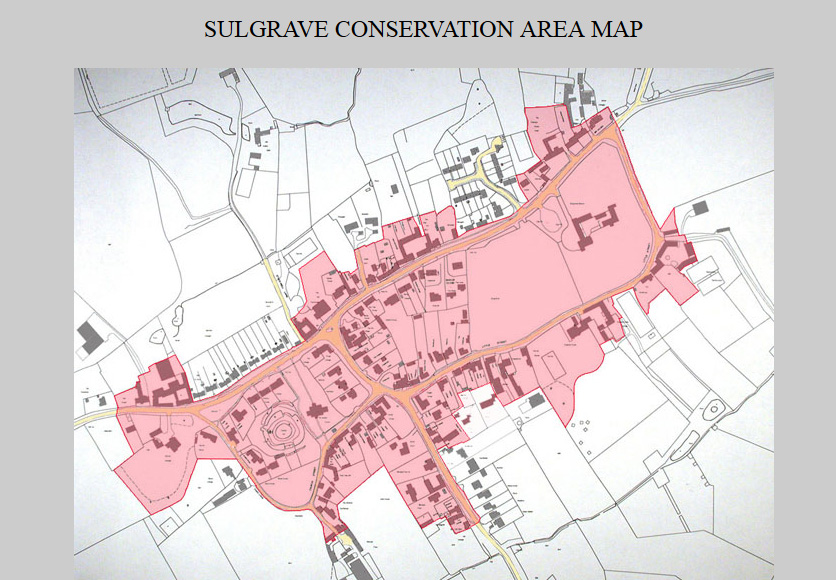
Conservation Area
There are no changes proposed to the Sulgrave Conservation Area.
CONSULTATIONS
South Northants Council has set out the arrangements for consultations on this latest version of the Local Plan as follows:
Hard copies of the document are available for inspection at the Council Offices at The Forum in Towcester and the District’s Libraries. There will also be a staffed exhibition at the Forum from 3.30 to 6.30 pm on Tuesday 30th October for people wishing to find out more about the Local Plan:
Comments are invited on the legal compliance, duty to co-operate and soundness of the Proposed Submission Local Plan and the Sustainability Appraisal that accompanies it.
Before responding, you are encouraged to read the Statement of Representation Procedure Notice which sets out details about the Proposed Submission Local Plan, the period for making representations, where documents can be inspected, how to make representations and a request to be notified about progress on the Plan.
All representations should be made using the prescribed response form. We encourage responses to be made online. The form can also be downloaded and returned via email, post or in person. All representations must be received by the District Council by to noon on Friday 16 November 2018. Responses received after this time will not be accepted.
To accompany the Proposed Submission Plan, a Sustainability Appraisal has also been produced to look at the economic, environmental, and social effects of the plan.
If you have any questions about the Proposed Submission Local Plan or the consultation arrangements please contact the Planning Policy Team:
- Email: [email protected]
- Telephone: 01327 322265
The documents can also be viewed at South Northamptonshire Council’s offices, in Towcester and at libraries across South Northamptonshire District. Copies of the Local Plan and inset maps can be purchased for £25 to collect, or £28 posted second class. Please call into the Forum Reception or phone 01327 322265. Payment can only be made by cheque (payable to South Northamptonshire Council).
Colin Wootton