HS2 (HIGH SPEED RAIL) – LATEST INFORMATION

INTRODUCTION
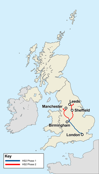
High Speed 2 (HS2) is a planned high speed railway which is aimed to be the new backbone of the national rail network, linking London, Birmingham, the East Midlands, Leeds and Manchester. The line is to be built in a “Y” configuration, with London on the bottom of the “Y”, Birmingham at the centre, Leeds at the top right and Manchester at the top left.
The project is to be built in two phases. Phase 1 is from London to the West Midlands and Phase 2 from the West Midlands to Leeds and Manchester. Phase 2 is split into two sub-phases, Phase 2a and Phase 2b. Phase 2a is from the West Midlands to Crewe. Phase 2b will extend the project from Crewe to Manchester and the West Midlands to Leeds.
The line of this high speed railway will pass approximately 1400 metres to the south-west of the nearest house in Sulgrave Village.
Details of the construction works in relation to the village set out on OS Maps can be seen by scanning down towards the foot of this page.
See here for an Interactive Map of the Route.
The permanent installation of this page on the Village Website is part of Sulgrave Parish Council’s adopted strategy in respect of HS2. The purpose of the page is twofold:
- To provide the latest information on the progress of the planning and implementation of the construction works in the vicinity of Sulgrave.
- To provide a simplified explanation of the extent and form of these works and the implications for the village and its inhabitants.
LATEST INFORMATION
BANBURY ROAD TO BE CLOSED FROM TODAY (12TH MAY 2025) FOR APPROXIMATELY TWO YEARS
This road closure was reported by Parish Council Chairman, Richard Fonge in February last as follows:
It is proposed to close the Banbury Road for two years from sometime this spring. This is to continue the green tunnel to join up with the viaduct on Banbury Lane. Banbury Lane is the lane from Thorpe Mandeville to Culworth which will be closed from time to time for the delivery of steel girders.
The Greatworth Tee Junction work was started last week on the B4525 (Welsh Lane). Latest information is that it will be completed by this Autumn. When completed traffic will turn right at the second roundabout on the new road and go over the tunnel to meet up with B4525.
With Banbury Road closed and traffic lights on B4525 for six months or so, we will have to allow extra time to get to Banbury.
Richard Fonge. Chair. Sulgrave Parish Council. 8th February 2025.

Local road layout whilst the Banbury Road is closed for the construction of the “Greatworth Green Tunnel”.
The HS2 Mobile Visitor Centre will be in the Car Park of Sulgrave Village Hall on Tuesday 19th September between 5.30 pm and 7.00 pm. The Contractor’s Staff (EKFB) will be available to take questions and provide feedback particularly on the construction progress of the Greatworth Green Tunnel and how this is affecting local highways.
At the Parish Council Meeting on 7th September 2023, Councillor Staples reported that the new connection between Sulgrave Rd and B4525 due to be opened on September 4th was now three to six weeks late. The new road had not passed inspection!! She would inform the village and attempt to get a more definite opening date.
UPDATE ON THE OPENING OF THE GREATWORTH “T” WORKS.
A highway inspection has been completed and it is now planned to open the new road on Monday 4th September.
A reminder of the new road layout:
- The main section of Sulgrave Road will remain closed for approximately 18-24 months while the Greatworth Green Tunnel is built.
- Phase 1: From 4 September, the new temporary road (Greatworth T) will keep traffic flowing to villages north of Greatworth.
- Phase 2: Next year, an additional section of temporary road will be added to keep traffic flowing along the B4525.
- See Plans below:


The above map shows the road closures and diversions which will be put in place to facilitate the construction of the Greatworth Temporary Road detailed in Councillor Staples’ report set out below.
JULY 2023 (Report to Parish Council by Councillor Sara Staples)

Road Closure – Magpie Junction to Bulls Lane, Thorpe Mandeville
Monday 20th February to Sunday 5th March 2023

The road coloured red between Points A and B will be closed 24 hours a day between Monday 20th February and Sunday 5th March 2023.
Closure of Footpaths AY12 and part of AY6

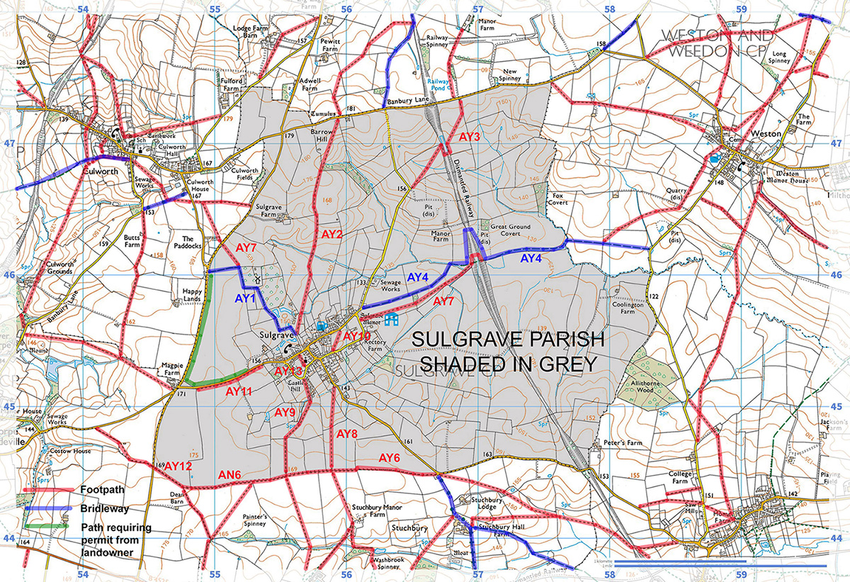
The footpath shown in red dashes between points “A” and “C” on the above map runs along the top of the broad ridge to the south of the village, connecting the Marston-St-Lawrence road and the Helmdon Road at Stuchbury Cottages. Designated as AY12, AN6 and AY6 on the definitive Rights of Way map, it is known to many villagers as the “Double Hedge Path” and forms a useful link in circuits around the Parish boundary.
The section of this footpath between Points “A” and “B” is now closed for the duration of the construction of HS2 and indeed much of this area is now covered with excavated material, as shown in the photograph below, taken at Point B:

On the completion of the tunnel, this material will be backfilled and consolidated to the same level as the surrounding land. Topsoil will be stored separately and will form the final layer in returning the area to agriculture, together with new landscaping and tree planting. The footpaths will be re-instated. Major projects of this kind are notorious for over-running their programmes and it would be a brave man who ventured to forecast a completion date!
Representations were made to HS2 and the contractors that this footpath closure will deprive villagers of a recreational circuit and discussions took place on the possibility of negotiating an alternative return route from Point B. It is anticipated that the Parish Council will continue to look into this
Proposed revised connection between Sulgrave and the B4525 north of Greatworth
In order to facilitate the construction of the Greatworth Green Tunnel and improve access to the site for delivery vehicles, HS2 now propose to construct a temporary road from the Magpie/Marston St Lawrence road eastwards to join the B4525 at the entrance to Greatworth Park, as shown on the drawing below:

There will be two roundabouts on this section of road: Roundabout 1 will be exclusively for HS2 construction and delivery vehicles. Roundabout 2 will provide a further connection to B4525 at the recently completed junction improvement for access to Greatworth. This will involve the closure of the Magpie/Marston St Lawrence road between the departure point of the new road and the “Marston St Lawrence crossroads” (see drawing above). HS2 consider that this new proposal will provide a safer route off B4525 Welsh Road for deliveries to Greatworth Green Tunnel Compound and provide more continuity of flow of other traffic to avoid possible queues at junctions. Basically, it would replace the currently dangerous “Marston-St-Lawrence Crossroads” on B4525 with a much safer roundabout junction on the proposed new temporary road.
The impact of this on the local road system during the railway construction period is shown on the map below:

See here for an enlargement of the central section of this map.
It will be noted that the road between the Magpie and the Thorpe Mandeville Bull’s lane junction will be closed for the duration of the construction of the tunnel portal. Thus traffic bound for Banbury via the B4525 will turn left at the Magpie, continue straight on at Roundabout 1 and turn right at Roundabout 2. Traffic bound for Thorpe Mandeville will leave this route to turn right at the foot of Thenford Hill.
The route from Sulgrave to Banbury via this new proposal will be a little less than one and three quarter miles longer than the present route via Thorpe Mandeville. However, the route from Sulgrave to Thorpe Mandeville itself via this new proposal will be approximately three miles longer than the present direct route via the Magpie. The route to Marston St Lawrence will be about one mile longer.
In order to facilitate the early construction of this new temporary road, a section of the Greatworth Green Tunnel will be built in advance of the remainder, as shown in blue on the first drawing above. It is hoped that the new road will be in place by the middle of next year.
The durations and timescales of all these proposals will be confirmed as the railway construction work progresses.

For the duration of the works, all of the footpaths shown blue on the above map will be closed. The very fine route from A to B along the “double hedge” will therefore no longer be accessible from the road at Point A. HS2 are conscious of this loss of amenity and are seeking to make the “double hedge” path into a circular tour with the provision of an alternative return route, possibly along the northern perimeter of the works to Stuchbury Manor Farm near to B4525.
Sulgrave Church Hall upgrade project supported by £75,000 HS2 Community Fund
Click here for HS2 Job Opportunities
Click here for details of HS2 “Green Corridor Prospectus” and map of Environment Projects along the route.
HS2 Works Notification: Archaeological excavation works Greatworth to Edgcote, November 2020 – June 2021
3rd November 2020. Report of a satisfactory outcome to discussions with the contractors re footpaths affected by the construction works.
See here for a pd file of an exchange of emails
Colin Wootton
21st October 2020. Report on an online seminar in respect of the design and construction of the Lower Thorpe and Edgcote viaducts.
I attended this seminar and asked a number of questions which I will deal with after the following general introduction
Colin Wootton

The above map shows the location of a construction compound (shown ringed) which is currently being installed near to the Magpie junction. It will comprise temporary offices, welfare facilities, car parking and HGV access. At a later stage the site will also accommodate a concrete batching plant. Once the railway is built the compound and associated facilities will be removed and the area returned to farmland.
For ease of reference, the entrance to this site is approximately 750 metres south of the Magpie Junction along the road to Marston St Lawrence (just opposite the sign indicating the footpath to Stuchbury).
South-east of Point A the railway will be in the Greatworth Green Tunnel, a name which reflects the method of construction i.e. the excavation of a large cutting alongside which the excavated material will be stored whilst the precast concrete sides and roof of the tunnel itself are installed, these then being covered by the excavated material and the whole area restored to agriculture with the planting of additional trees.
Continuing its route north-westwards the railway will emerge from the tunnel at Point A and follow a cutting under the road to Banbury at Point B and then on a short embankment until it crosses the viaduct to be built at Point C.

Artist’s impression of the proposed Lower Thorpe Viaduct.
The current programme envisages the construction of the Lower Thorpe Viaduct commencing in December 2021 with completion in July 2023.
Whilst the nature of the topography between Sulgrave and the line of the railway together with the Greatworth Green Tunnel mean that there will be minimal visual impact upon the village, sound pollution is a different matter. In particular, I asked about the possibility of a “sonic boom” when a train at 300 mph plus emerges from the tunnel at Point A. The civil engineer who answered the question said that they were designing what he called a “porous portal” with slots in the material through which the sound waves would be dissipated.
One of the main concerns for the village must be the impact of the construction itself, in terms of noise and traffic movements, for a period of more than a decade. There will inevitably be deep foundations to the supporting piers of the viaduct and I asked what steps would be taken to minimise the incessant sound of pile driving. The reply was that modern technology involved digging out the slots for the piles to minimise the need for the traditional hammering method.

The blue dots on this map indicate the routes to which HS2 construction traffic is to be confined but, of course, the presence of long duration major engineering works so close to Sulgrave must mean additional general traffic through the village.
Thorpe Mandeville is in a far less fortunate position than Sulgrave in respect of construction traffic. The original intention was that construction traffic for the Lower Thorpe Viaduct would use the Thorpe Mandeville to Culworth minor road. I asked what steps were being taken to mitigate this impact upon the village and was told that it was now planned that precast concrete sections and other materials for the viaduct would be delivered via B4525 and the Marston to Sulgrave Road to the Construction Compound at Point A and then along the railway formation itself to the viaduct at Point B.
It must follow that a large number of construction vehicles of all kinds will use the roads from Sulgrave to both Banbury and Marston St Lawrence. There are already traffic delays along these roads simply for the early works involved in the installation of the Construction Compound and these can only get worse.
With construction works also affecting traffic on the road from Helmdon to Brackley it may be that villagers will perhaps need to replace Banbury with Towcester as their main shopping and service centre and commence rail journeys to London from Milton Keynes.
Traffic Management plans for the construction traffic are currently under consideration and will be reported on this website as soon as they are available.
HS2 Community Funds award £75,000 to Brackley Town FC for new clubhouse
Welsh Lane road closure near to Aston-le-Walls

Click here for further details.
HS2 issues Notice to Proceed
Posted on Apr 16th 2020 by HS2 in Northamptonshire
On 15 April 2020, the Department for Transport gave approval for HS2 Ltd to issue Notice to Proceed to our four Main Works Civils Contractors (MWCC) working on Phase One of the project.
The issuing of Notice to Proceed marks the point in the MWCC contracts where work transitions from scheme design and preparatory work, to full detailed design and construction of the railway between London and the West Midlands.
You can find further information on both gov.uk and the HS2 website.
The four contractors along the phase one route – SCS Railways, Align JV, EKFB JV and BBV JV – will start the second stage of their contracts immediately, progressing detailed design, site preparation works and placing important sub-contracts. During this period, our contractors are continuously reviewing their ability to work within Public Health England guidelines to ensure the health, safety and wellbeing of our workforce and the communities in which we are working.
HS2 Construction gets the green light despite lockdown
Owing to the coronavirus pandemic, work at the majority of HS2 sites is to be paused while a review is carried out to ensure that all activities comply with Public Health England guidelines.
Installation of a Construction Compound

The above map shows the location of a construction compound to be installed in Spring 2020. It will comprise temporary offices, welfare facilities, car parking and HGV access. At a later stage the site will also accommodate a concrete batching plant. Once the railway is built the compound and associated facilities will be removed and the area returned to farmland.
For ease of reference, the entrance to this site will be approximately 750 metres south of the Magpie Junction along the road to Marston St Lawrence (just opposite the sign indicating the footpath to Stuchbury).
A Consultation Document has now been published by HS2 in respect of the Common Design Elements of the Railway. Comments are required before 30th January 2020. See here for details.
HS2 site walk and Q&A session.

Villagers at the crossing point of the proposed HS2 railway line and the road from the Magpie to Marston-st-Lawrence during a walk and site visit with the Contractor’s engineers.
During the visit it was announced that that there was a possibility of the reinforced concrete sections for the tunnel under the green cutting being constructed on site at the Satellite Compound near Magpie Farm. Several villagers expressed concern about the possibility of continuously noisy and dusty manufacturing operations close to Sulgrave, possibly with large silos for the materials.
Subsequently, clarification was sought by email and this was the response from Chris James of Eiffage Kier JV:
With regard to the points that you raise:
- I explained that the tunnel construction was expected to be precast concrete. The precast units will be delivered from a manufacturer in the NE of the country, deliveries will travel down the M1 and then West along the A43. One of the reasons for selecting this option is that this method reduces the number of traffic movements on the highway.
- I also explained that we intended to set up a concrete batching plant in our compound at the magpie junction area. This will be within the area allocated for a construction compound. Concrete will be made at the batching plant and then distributed along the site access road that we will have constructed and used in concreting activities aside from the precast elements. Again, one of the key reasons for doing this is to reduce traffic movements on the highway. I made a particular point to emphasise how well controlled these operations are and they will not impact on Sulgrave from a dust and noise perspective. I have set concrete batching plants up in residential areas and the silos are sealed and regulations are strict that set out how these activities are operated.
I hope this addresses your queries though do let me know if you have any further questions Colin,
Best regards
Chris
News Update: Funding awarded to improve Marston St Lawrence Village Hall.
Grant Aid from HS2 Community and Environment Fund approved for Church Hall Improvements.
Appointment of an agricultural contact to deal with problems and requests connected with the works:
Nick Smith (EK)
Agricultural Liaison Officer
Mobile: +44 (0) 7824 461397
Latest from HS2 Management – October 31st 2018
Preliminary works are taking place near to the village, such as drilling for soil and subsoil samples, the establishment of compounds and setting out. It is anticipated that the contractors will commence the actual construction work in the Sulgrave area, comprising the Greatworth green tunnel and associated road bridges, in the second half of 2019. However, it seems that there is still much work to be done to finalize the design, programme and construction methodology.
The improvement work to the Greatworth junction with the B4525 should start in the new year, commencing with a compound set up and then progressing to the new junction layout. Misleadingly for Sulgrave inhabitants, both HS2 and the contractors continue to call this the “Sulgrave Junction”, presumably because the road between Greatworth and the B4525 is known as “Sulgrave Road”. This work should be completed by spring 2019. Just to reiterate that no improvement works are proposed for the Magpie junction.
The main impact of the construction work on footpaths in Sulgrave Parish involves footpath AY12, which commences just over half a kilometre south of the Magpie on the road to Marston St Lawrence. For almost 300 metres this footpath heads south east along the line of the hedgerow which encloses what might be called the large Magpie field. It then joins the footpath along the double hedgerow leading due east to the Stuchbury cottages. Footpath AY12 is right on the edge of the land to be taken for construction. Its fate is currently undecided and will be in the hands of the contractors. It may be that they can complete the work without disturbing it or they may apply for a closing order. Hopefully it will remain open at least until the middle of next year and possibly permanently.
Click here for latest information from HS2 (30th September 2018)
HS2 Community Engagement Meeting in the Church Hall on Thursday 27th September, 7 to 9 pm.
JULY 2018. The start date for High Speed 2 civils works has been delayed until June 2019, the Department for Transport (DfT) has confirmed.
The notice to proceed (NTP) has been pushed back a further three months.
Parliamentary under secretary of state for transport Baroness Sugg confirmed the delay, stating “Following consideration of supplier feedback, the HS2 Ltd Board has recently decided to move the date of Notice to Proceed from 1 March 2019 to 1 June 2019 in order to provide suppliers with additional time to optimise their designs.
“HS2 Ltd’s latest advice to government is that Phase One remains on track to deliver HS2 services by 2026 and within the agreed funding envelope, in accordance with the Sponsors’ Requirements as set out in the Development Agreement.”
HS2 Senior Project Manager Dave Williams writes (2nd August): “……this does not mean that work will be delayed in this area. The Enabling Works contractor is in full swing and it will be this contractor who will deliver the works at Sulgrave, Chipping Warden, Wardington etc……in fact they are due to start mobilising for constructing Chipping Warden relief road in the next couple of weeks, having already completed archaeological works, surveys etc.”
Contracts have been let in respect of that section of the line which affects Sulgrave. With the demise of Carillion, the contractors are Eiffage and Kier. The contracts will be let in two stages. Stage One is a 16 month period to develop a design, a programme and a target cost for the construction of the works. Stage Two is for the construction of the main works and this is expected to take between four and five years to complete.
Scheme design is expected to be completed by December 2018, followed by a period of review and assurance, with the main civil engineering works anticipated to start in the Sulgrave area around Spring 2019 (subject to finalising the contractor’s programme of activities). The general civil engineering work is expected to be completed by 2023 followed by a two year period for the installation of the railway systems, signalling and overhead lines. Following a year of systems testing, the line is expected to be in use by 2026 or 2027.
THE HS2 COMMUNITY AND ENVIRONMENT FUND (CEF)
The CEF fund has been created: “…… to add benefit over and above committed mitigation and statutory compensation to communities along the route that are demonstrably disrupted by the construction of Phase One of HS2 from London to West Midlands.” Communities coming into that category are invited to make applications for grant funding of up to £75,000, which is to be targeted at the voluntary/community sector, including residents’ associations, constituted community groups and so on. Possible uses of the grant funding includes the provision of enhanced or new community facilities.
Sulgrave evidently qualifies as a village which will be “demonstrably disrupted” by the construction works and which could certainly find a use for funds to the benefit of the community. With this in mind, an application for funds to improve the Church Hall is being made by Ingram Lloyd on behalf of the Parochial Church Council (the building being in Church ownership) and Councillor Anna Faure on behalf of the Parish Council, whose latest report on progress can be seen here.
A village meeting to discuss this matter was held in the Church Hall on Thursday 12th April. See here for details.
CONSTRUCTION WORKS IN THE VICINITY OF SULGRAVE VILLAGE
The engineering drawings for the project are necessarily complex and do not show the relationship of the construction site to Sulgrave village.
The map below has therefore been prepared so as to indicate on an Ordnance Survey base, which also shows the village, the approximate area of land potentially required during construction (shaded pink). This is not an HS2 document but has been prepared with reference to HS2 drawings CT-05-070 and CT-05-071.

The works will be undertaken in such a way that a route to Banbury via the B4525 and A422 will be kept open at all times.

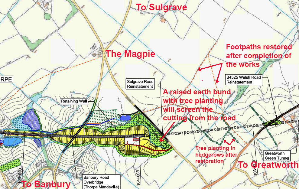
Over the land coloured green on the above map the railway line will be constructed as a cutting at the foot of which will be a prefabricated tunnel. This will then be covered to form what is to be known as the “Greatworth Green Tunnel”. Over the land coloured blue the line will be in an open cutting between the Sulgrave Road and the Banbury Road and then on an embankment and viaduct crossing the valley at Lower Thorpe.

Representation of the method of constructing the tunnel at the foot of the cutting.
Excavated material will be stored predominantly on the NE side of the cutting and within the boundaries of land coloured green on the above map, where it will form a temporary “bund” which may be helpful in mitigating the noise of construction.
On the completion of the tunnel, this material will be backfilled and consolidated to the same level as the surrounding land. Topsoil will be stored separately and will form the final layer in returning the area to agriculture, together with new landscaping and tree planting.
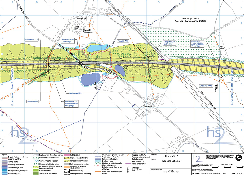
More details of the area after the completion of the construction works can be seen on the HS2 map below:

See here for a bigger version of this map.
The sequence of operations for the construction and reinstatement of the Sulgrave and Banbury roads is likely to be as follows:
Construct temporary diversionary roads to Local Highway Authority standards, at existing ground level to bypass the construction works.
Divert traffic onto temporary diversions (this will be maintained until the new roads are complete).Excavation under the existing roads to railway line level.
Construction of short sections of tunnel/cutting under existing roads.
Construction of the new overbridges and new roads on or near the existing alignments.
Open new roads and remove temporary road diversions.
Construction of the remainder of the “Greatworth Green Tunnel” and restoration to agriculture.

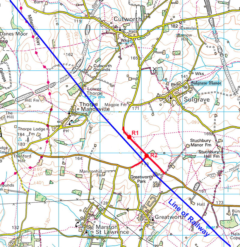
See here for details of the Radstone crossing.
IMPACT ON LOCAL FOOTPATHS

Footpaths shown in blue dots will be stopped up for the duration of the works and re-opened upon completion. Other footpaths shown in small green dashes will remain open throughout.
The footpath between Points A and B on the above map is one of the most attractive in the village, following the top of a broad ridge with panoramic views of the village. It also follows a “double hedge” which is described in the Village Website Parish Appraisal as being “….at least 500 years old by Hooper’s Rule….including species which offer a virtual larder of fruits, nuts and berries for both birds and animals alike….” Those who have not enjoyed a walk in this currently tranquil area are advised to do so during the next few months…..
Photographs taken along this route were included in Parishioner Ken Christy’s Petition to the HS2 Parliamentary Select Committee and can be seen by clicking on these two Appendices to that petition:
Appendix 1 – Map showing the photograph viewpoints.
Appendix 2 – The photographs.
ROUTES FOR CONSTRUCTION TRAFFIC IN THE SULGRAVE AREA

Approximate line of HS2 shown in red. Roads designated on HS2 drawings as “Construction Traffic Routes” are shown in blue dots. No construction traffic through Sulgrave Village. Regional routes for construction traffic will be:
M40 Junction 11 via A361
M40 Junction 11 via A422 and B4525
M40 Junction 10 via A43 and B4525
M1 Junction 11 via A45 and A361
The HS2 Environmental Assessment for this area predicts that during the construction period “changes in traffic flows will lead to significant increases in delays to vehicle users and congestion at the junction of A422 and A361 (M40 Junction 11 to the east of Banbury)”
Despite re-assurances that construction traffic will not be allowed through Sulgrave, it is inevitable that there will be an increase in general traffic flows during the construction period. Whilst this will be unwelcome, there may be some compensation in the probability of additional customers for the Community Shop, The Star and the providers of overnight accommodation.
SATELLITE COMPOUNDS
A number of Satellite Compounds will be located in the vicinity of the village. These are shown on the map below:

The following information about each Satellite Compound has been extracted from HS2 documents but details may change as the design work progresses (construction traffic access routes to the compounds shown in blue dots):
1. Lower Thorpe Viaduct Satellite Compound
This compound will be used for civil engineering works only, adjacent to Lower Thorpe. The compound will be operational for approximately two years, start date to be advised.
It will support approximately 110 workers each day throughout much of this period; increasing to a maximum of approximately 190 workers each day during the peak period of activity. It will not provide worker accommodation. It will be accessed via Banbury Lane (the road from Thorpe Mandeville to Culworth via Lower Thorpe) from the M40, A422 and B4525 and/or the M40, A43 and B4525 from the west.
Demolitions will be required at two properties: residential property (Twin Oaks and two associated outbuildings) at Banbury Lane and residential property (Lower Thorpe Farmhouse (Grade II listed) and two associated outbuildings) at Banbury Lane.
Diversions of two roads will be required: temporary closure of Banbury Lane with temporary alternative route via Banbury Road, for a period of approximately one to two months, then permanent reinstatement along its existing alignment and permanent reinstatement of Culworth Grounds private access, 80m to the south via the new Culworth Grounds accommodation overbridge. A temporary alternative route for Banbury Lane footpath will be required, to the north for a period of approximately one year and six months to two years, adding an additional 600m. It will then be permanently reinstated along its existing alignment.
2. Thorpe Mandeville Cutting Satellite Compound
This compound will be used for civil engineering works only, adjacent to Thorpe Mandeville. The compound will be operational for approximately two years, starting time to be advised.
It will support approximately 30 workers each day throughout much of this period; increasing to a maximum of approximately 45 workers each day during the peak period of activity. It will not provide worker accommodation.
It will be accessed via Banbury Road from the M40, A422 and B4525 from the west. It will have an associated roadhead with access to/from Banbury Road for the receipt, storage and transfer of earthworks material route-wide (see Map CT-05-071). This storage area is on the opposite side of the road to the compound and is shown shaded in blue on the above map.
3. Greatworth Green Tunnel (North Portal) Satellite Compound.
This compound will manage railway systems installation works only, from approximately Greatworth to Thorpe Mandeville. The compound will be operational for approximately one year and six months, starting in 2022.
It will support approximately 10 workers each day throughout this period. It will not provide worker accommodation. It will be accessed from the M40, A422 and B4525 from the west.
4. Greatworth Green Tunnel Satellite Compound.
This compound will be used for civil engineering and railway installation works, between Greatworth and Thorpe Mandeville. The compound will be operational for approximately six years and six months, including civil engineering works for approximately four years and six months, commencing at a date to be advised and railway installation works for approximately two years and three months, starting in 2021.
It will support approximately 145 workers each day throughout the civil engineering works period; increasing to a maximum of approximately 235 workers each day during the peak period of activity; and support approximately 20 workers each day throughout the rail systems installations works period increasing to a maximum of approximately 40 workers each day during the peak period of activity. It will not provide worker accommodation.
It will be accessed via A43 and B4525 from the east and via the M40, A422 and B4525 from the west.
Demolitions will be required at two properties: two buildings occupied by two motorsport engineering businesses: Triple Eight Race Engineering and MP Motor Sport Ltd, part of the former World War II wireless reception and intervention centre at Greatworth Park; and commercial property (one building and one outbuilding at Dean Barn) near Sulgrave Road.
NOISE
It is difficult to estimate the probable noise impact upon the village of the works in progress. The best that can be said at the moment is that working hours will be restricted to 08.00 to 18.00 on weekdays and 08.00 to 13.00 on Saturdays. Given the nature of the local geology, it seems unlikely that blasting will be necessary in the excavation of cuttings. Some pile driving activity may be necessary but this is less noisy that was once the case.
AGRICULTURE
The contractors will have appointed agricultural liaison officers (ALO) to liaise with local farmers and landowners as the work progresses.
Much of the information in the above description of the proposed construction works is derived from the “London – West Midlands Environmental Statement, Volume 2 – Community Forum Area Report -Greatworth to Lower Boddington” Click here to access the report itself.
SEVEN YEARS OF LIVING WITH THE THREAT OF HS2
Despite huge efforts by many people at both national and local level, the threat of the construction of a high speed railway within 1400 metres of the village has now become a reality.
However, those efforts should not be forgotten and I therefore set out below links to relevant items which have appeared on this website during the seven years.
Sulgrave Parish Council Petition to Parliament in 2016. Following on from the petition, HS2 were directed to assure the Parish Council that there would be continued consultation as the design work progresses and the contractors are therefore contractually obliged to honour this assurance. A transcript of the hearing of the Parish Council’s petition, presented by then Councillor David Walker, can be seen here.
In the context of representations concerning HS2 made on behalf of Sulgrave, the dedication and hard work of former Parish Council Chairman Ken Christy should not be forgotten. Newer villagers may not be aware of his appearance before the Select Committee as a petitioner. See here for the very comprehensive case made in the petition.
February 2011
News item about protest demonstration in Thorpe Mandeville, with full details of the “Stop HS2 organisations”
May 2011
Government consultation. Full details of the scheme with maps and links to SNAG opposition group. How to make your views heard etc.
Dec 2012
https://sulgrave.org/2012/12/high-speed-rail-line-consultation-on-compensation-proposals/
Consultation on compensation proposals.
May 2013
https://sulgrave.org/2013/05/draft-environmental-statement-published-for-high-speed-rail-route-hs2/
Links to the draft environmental statement with an explanation. Notice of a meeting to be held at the Manor on May 28
December 2013
https://sulgrave.org/2013/12/final-consultation-on-hs2-high-speed-rail-line/
Final consultation on HS2. Maps and full details of the impact of the scheme on the area both during and after construction
February 2014
https://sulgrave.org/2014/02/extension-to-consultation-period-for-high-speed-rail-line/
Details of the extension to the consultation period with full details of impact on this area.
April 2017
https://sulgrave.org/2017/04/high-speed-railway-hs2-community-update/
Community update, what’s happening etc.
October 2017
Report on HS2 event held at Sulgrave Manor on October 17th.
Colin Wootton
Note: All extracts from OS maps featured on this website page are published under licence from the Ordnance Survey. All rights reserved.