
District-wide Local Plans contain policies and proposals which guide decisions on the use and development of land during a prescribed period. They are prepared by District Councils in accordance with relevant National and Regional planning policies, in consultation with all interested parties and organisations and the general public.
The current Local Plan for South Northamptonshire was adopted by South Northamptonshire Council in 1997. The Council is preparing a replacement plan for the period up to 2029 which will, amongst other things, establish a Rural Settlement Hierarchy for settlements within the District; propose amendments to existing town and village confines lines, beyond which expansion will not normally be permitted; identify areas of important open space within settlements and address local development needs.
In 2016, the Council published a consultation document inviting comments on the various options then under consideration in respect of these matters.
Numerous responses were received, including those from Sulgrave Parish Council. After due consideration of these responses, the Council has now published its Pre-Submission Draft Plan for Consultation.
See next page for further details, including links to the relevant documents.
The policies and proposals of the plan are legally required to accord to the to the provisions of the National Planning Policy Framework (NPPF) and give effect to the objectives of The West Northamptonshire Joint Core Strategy Local Plan (Part 1). This Joint Plan sets out the long-term vision and objectives of the whole area covered by Daventry District, Northampton Borough and South Northamptonshire District Councils for the plan period up to 2029, including strategic policies for steering and shaping development. It identifies specific locations for new housing and employment and changes to transport infrastructure and other supporting community facilities, as well as difining areas where development will be limited.
The Joint Core Strategy provides for the following housing provisions in the plan period:
Daventry District 12,730
Northampton Borough 18,870
South Northamptonshire 11,020
The South Northamptonshire allocation is distributed as follow:
Brackley Town 2,160
Towcester Town 2,650
Northampton Related Development Area 3,850
South Northamptonshire Rural Areas 2,360
In order to meet the housing allocation to the South Northamptonshire Rural Areas, the Pre-Submission plan sets out a hierarchy of villages, with the bulk of the total expected to be accommodated in:
PRIMARY SERVICE VILLAGES
Bugbrooke, Deanshanger, Middleton Cheney and Roade
and
SECONDARY SERVICE VILLAGES
Ashton, Aynho, Blakesley, Blisworth, Boddington (Lower and Upper), Brafield on the Green, Chacombe, Charlton, Chipping Warden, Cogenhoe, Cosgrove, Croughton, Culworth, Denton, Evenley, Farthinghoe, Gayton, Grange Park, Greatworth, Greens Norton, Hackleton (with Piddington), Harpole, Hartwell, Helmdon, King’s Sutton, Kislingbury, Litchborough, Little Houghton, Milton Malsor, Nether Heyford, Old Stratford, Pattishall (Astcote, Eastcote and Fosters Booth), Paulerspury (with Pury End), Potterspury, Rothersthorpe, Silverstone, Stoke Bruerne, Syresham, Tiffield, Weedon Lois (Weston) Whittlebury, Yardley Gobion and Yardley Hastings
The remaining villages are classed as:
SMALL SETTLEMENTS
These are:
Abthorpe, Adstone, Aston le Walls, Bradden, Caldecote, Courteenhall, Eydon, Grafton Regis, Hinton in the Hedges, Horton, Maidford, Marston St Lawrence, Moreton Pinkney, Quinton, Shutlanger, Slapton, Sulgrave, Thorpe Mandeville, Whitfield, Wicken, Wood Burcote, Wappenham, and Wootton Fields
In these villages there will be scope for very limited development within or adjoining the village confines of the settlement (my italics) where this is limited to meet any identified local or specialist need or where there are opportunities for the redevelopment of brownfield sites which will result in a positive environmental improvement. However, the plan makes clear that any application including the development of open market housing on sites outside the village confines will need to be accompanied with evidence that alternative sites within the confines are not suitable or available for development. In addition, the application will need to be supported by a robust local objectively assessed needs study, undertaken in conjunction with the Parish and District Councils over an appropriate period.
The Council’s proposals for the extent of the confines in Sulgrave are set out in Annex 8 (1). The plan in the annex is rather small and the confines line somewhat difficult to discern and so I have prepared the following three maps to show it in more detail.


Since the publication of the Options Consultation Document, the Council has made a number of small amendments to the confines line for Sulgrave and these are shown in red dots. The changes are basically made so that the line follows garden boundaries rather than arbitrarily cutting across properties as in the past. The line also reflects the granting of planning permission for housing development off Little Street.
Special Landscape Areas
In recognition that some areas are of greater landscape value than others, many years ago Northamptonshire County Council designated a number of Special Landscape Areas (SLAs) across the district. As part of the Local Plan Part 2 the Council has completed a review of the landscape of the district. This review considered a number of factors including the distinctiveness of the landscapes, their scenic quality, natural and cultural character and function. For the first time, Sulgrave and its sourrounding landscape are included in this designation.
This newly designated area is to be called “Sulgrave & Great Central Railway” and is described as:
“an intimate landscape characterised within the topography given by the transition of the landscape character from the Northamptonshire Uplands to the Northamptonshire Vales and the Yardley – Whittlewood Ridge.”
Once more, the published map showing this newly designated area is somewhat difficult to follow and that shown below is my own interpretation.

It should be noted that the Eydon, Cuworth and Thorpe Mandeville areas to the west are already designated as Special Landscape Areas.
While such areas do not have the status of national designations such as “Areas of Outstanding Natural Beauty”, the designation does give further protection from unsuitable developments. The policy for such areas states: “…… the Council will seek to conserve and enhance the quality of the landscape and development opportunities within those areas will be limited because of their special environmental quality.”
In addition, the disused railways shown dotted on the map are to be designated as “Strategic Green Corridors” about which the Plan states “It is considered important that there are safeguards to maintain the continuity and identity of these historic corridors and their place within the history of South Northamptonshire and to ensure they continue to contribute to the wider visual quality of the landscape of South Northamptonshire whilst providing a significant wildlife environment and habitat together with potential recreational opportunity. The Council will seek to conserve and wherever possible enhance green infrastructure along these routes.
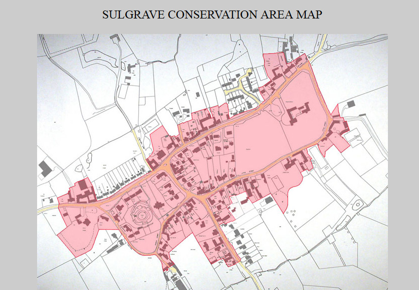
Conservation Area
There are no changes proposed to the Sulgrave Conservation Area.
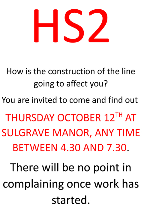
High Speed Rail (HS2)
The Local Plan contains the following reference to HS2:
High Speed Rail (London – West Midlands) Act 2017 gained royal assent on 23rd February 2017. The proposed route passes through South Northamptonshire and will have a major impact on the environment and local communities in the plan area. Under the 2017 Act South Northamptonshire Council is a Qualifying Authority with responsibility for issuing consents and approvals in respect of the detailed design and appearance of structures and other elements of the scheme, but not the principle of the construction which is permitted by the Act itself. The Council will expect proposals for the development of the HS2 to have special regard to the landscapes of the route, biodiversity and geodiversity. Any loss to these should be fully mitigated and compensated with opportunities taken to address the shortfalls identified in the Northamptonshire Biodiversity Action Plan and wider landscape enhancements. The use of native species is encouraged as will the enhancement of existing and creation of new biodiversity and green infrastructure corridors and habitats.
It is strongly suggested that everyone who can should visit the HS2 event to be held at Sulgrave Manor on Thursday 12th October between 4.30 pm and 7.30 pm when an HS2 team will be on hand to answer your questions.
In this brief summary of a lengthy and complex document I have attempted to draw out those matters of particular relevance to Sulgrave residents. This should not prevent everyone from making a careful consideration of all the policies and proposals set out in the Local Plan documents and taking the opportunity to comment upon those which are found to be of particular concern or interest.
A useful summary of the Plan may be found here.
Remember to submit your comments, either online or by visiting a local library, before noon on Friday 10th November 2017.
Representations on the Plan must be made in writing. The Council strongly encourages responses to be made on-line via the Council’s interactive consultation system Please view and comment online at
http://www.southnorthants.gov.uk/8470.htm
or by email to [email protected]
However if you are unable to provide your comments using the Council’s interactive consultation system or email you can submit your comments by post to the address below:
Planning Policy Team Pre-submission Draft Local Plan Part 2 South Northamptonshire Council The Forum Moat Lane Towcester NN12 6AD
A further public consultation will take place in Spring 2018 and relevant modifications will be made before submitting the draft plan for examination by an independent inspector in Summer 2018. Examination in public and adoption will take place late 2018.
Colin Wootton